Establishing UplinkOperations

3D Visual Intelligence
GAUSSIAN SPLAT
DRONE CAPTURE
FOR IMMERSIVE
SITE VISUALISATION
Photorealistic 3D visualisation created from drone and ground-level imagery — helping clients explore, present and preserve real-world sites beyond flat photos or video.
Immersive viewingSite visualisationStakeholder presentationDigital twin-style records
01 · Showcase
INTERACTIVE
GAUSSIAN SPLAT DEMO
Explore a representative Gaussian Splat capture to see how photorealistic 3D visualisation can help stakeholders understand a site from multiple viewpoints.
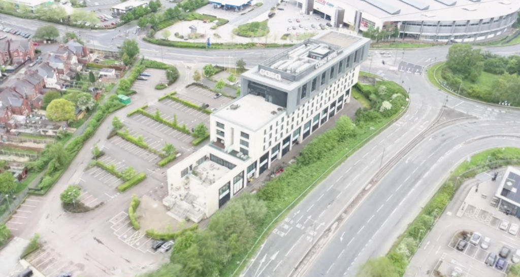
Altitude Command Centre Demo
A photorealistic 3D reconstruction of a commercial development site.
Interactive viewer coming soon
This demo is provided as a visualisation example. Final output quality depends on site conditions, image coverage, lighting, capture workflow and processing.
Gaussian Splat Visualisation• Works best on modern desktop devices
02 · Clarification
WHAT IS A
GAUSSIAN SPLAT?
A Gaussian Splat is a photorealistic 3D scene reconstructed from overlapping images. Instead of viewing a site as flat photographs or a fixed video, users can explore a captured environment from different angles and viewpoints.
For commercial clients, the value is not the technology itself. The value is the ability to preserve, present and communicate a real-world location as an immersive visual asset.
Commercial Value Drivers:
- Immersive site visualisation
- Property and development marketing
- Construction progress records
- Heritage and conservation documentation
- Stakeholder briefings
- Film and location scouting
- Public consultation
- Digital twin-style visual records
03 · Utility
WHERE GAUSSIAN SPLATS
ADD COMMERCIAL VALUE
Property & Development
Help investors, buyers, tenants or planning stakeholders understand a site through immersive visual context.
Construction Progress
Capture project stages and site conditions as visual records for stakeholder updates and future comparison.
Heritage & Conservation
Preserve historic buildings, estates and sensitive environments as photorealistic visual records.
Public Consultation
Help non-technical stakeholders understand the layout, scale and visual context of a real-world location.
Facilities & Asset Management
Create visual records of buildings, roof zones, plant areas, estates and access-restricted assets.
Insurance & Claims
Support visual records of site condition, access constraints or damage context where immersive understanding is useful.
Film & Location Scouting
Allow creative teams to assess sites remotely using immersive visual context.
Venues & Tourism
Create engaging visual experiences for venues, estates, destinations and visitor attractions.
04 · Benchmarking
GAUSSIAN SPLAT VS
TRADITIONAL 3D OUTPUTS
| Output Type | Best For | Strengths | Limitations |
|---|---|---|---|
| Gaussian Splat | Photorealistic visualisation and immersive walkthroughs | Realistic visual feel, stakeholder engagement, site presentation | Not survey-grade by default; measurement-critical work needs additional workflow |
| Photogrammetry | 3D models, meshes, orthomosaics and measurable outputs | Can support mapping, modelling and measurement workflows | Accuracy depends on capture/control workflow; may look less photorealistic |
| LiDAR | Point clouds, terrain, vegetation, complex geometry and survey data | Strong geometry and point-cloud outputs | Less visually photorealistic; specialist hardware/processing required |
| 360 Panorama | Fixed-point immersive viewing | Lightweight, easy to embed, useful for context | Limited movement; not full 3D reconstruction |
| Drone Video | Guided storytelling and marketing | Shareable, simple, strong emotional impact | Viewer cannot freely explore the scene |
05 · Execution
HOW GAUSSIAN SPLAT
CAPTURE WORKS
01
Define Purpose
We confirm whether the output is for property, construction, heritage, consultation, insurance context, media or asset records.
02
Plan Route
Drone and ground-level image capture is planned around coverage, overlap, lighting, access and visual continuity.
03
Capture Images
The site is captured from multiple aerial and ground-level viewpoints to provide high visual density.
04
Process Model
The Gaussian Splat is processed, reviewed and cleaned where required to reduce artefacts or visual noise.
05
Deliver Outputs
Outputs can include screenshots, flythrough video, web-ready viewer or source files depending on scope.
06 · Outputs
Gaussian Splat Deliverables
Gaussian Splat Visualisation
The core immersive scene.
Screenshot Set
Extracted high-res perspectives.
Flythrough Video
Guided cinematic site tours.
Web-Ready Viewer
Browser-based interactive format.
Digital Twin-Style Record
Visual spatial documentation.
360 Aerial Panorama
Complementary contextual views.
07 · Disclaimer
VISUALISATION FIRST,
MEASUREMENT SECOND
Gaussian Splats are powerful visualisation assets, but they should not be treated as survey-grade by default. They are ideal for photorealistic walkthroughs, stakeholder engagement, visual site records and immersive presentations.
For measurement-critical projects, Gaussian Splat capture should be paired with appropriate photogrammetry, LiDAR, RTK, ground control or survey-controlled workflows where required.
Technical Guidance:
Use Gaussian Splat when you need people to experience the space. Use survey-controlled photogrammetry or LiDAR when you need verified measurements. Use both when the project needs visual impact and technical data.
08 · Recommendation
IMMERSIVE DIGITAL CAPTURE PACK
For clients who need Gaussian Splat capture alongside drone imagery, 360 panoramas, photogrammetry, flythrough video or digital twin-style visual records, the Immersive Digital Capture Pack provides a structured route from capture to usable visual deliverables.
VIEW IMMERSIVE DIGITAL CAPTURE PACK09 · Support
GAUSSIAN SPLAT FAQ
A Gaussian Splat is a photorealistic 3D reconstruction created from overlapping images. It allows users to explore a captured environment from different viewpoints instead of viewing it only as flat photos or video.
Gaussian Splats are usually created from carefully captured overlapping imagery. Drone imagery can be used, especially when combined with ground-level capture for better coverage and visual continuity.
Not by default. Gaussian Splats are primarily visualisation assets. For measurement-critical work, capture should be combined with photogrammetry, LiDAR, RTK, ground control or survey-controlled workflows.
It is best for immersive visualisation, stakeholder engagement, site records, property marketing, construction progress, heritage documentation, public consultation and location scouting.
Yes, where technically suitable. A web-viewable model can be prepared using an appropriate viewer workflow. For performance reasons, interactive models should usually load on demand rather than automatically.
Photogrammetry is often used for measurable 3D models, meshes, orthomosaics and survey-related outputs. Gaussian Splats usually provide a more photorealistic viewing experience but are not automatically measurement-ready.
NEED TO CAPTURE A SITE
PEOPLE CAN EXPLORE,
NOT JUST VIEW?
Gaussian Splat drone capture gives clients a more immersive way to present, preserve and understand real-world spaces. Tell us what you need to visualise, and we’ll recommend the right capture workflow.